The new 3D Cadastral System of the State of Israel
Project Name: The new 3D Cadastral System of the State of Israel
Client: Survey Office of Israel (Ministry of Construction and Housing)
Country: Israel
A 3D Parcel is a volumetric unit which its boundaries are registered in 3D. It can be above or under the ground level, or a combination of them, meaning that its borders will be defined from a certain depth below the surface of the ground to a certain height above the surface of the ground. In the 3D Parcel, separate rights will be registered for the plot owners.
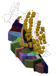
A 3D Cadastral Plan (CAD)
Following the new 3D land registration law (an amendment to the Real Estate Law) that was passed by the parliament of the state Israel, the Survey Office Israel (SOI) was required to implement the new law by supporting the registration of 3D Parcels.
Accordingly, the SOI published a public tender which included 2 stages – pre-qualification and Proof of Concept (POC) stage, and a combined technical and financial bidding stage. Following this tedious process, and due to its unique technological and expertise advantage, Sivan Design was awarded the project with a 2 years development and implementation period, and 7 years maintenance term.
The project includes the development, deployment and implementation of a technological infrastructure for the management of Parcels in 3D, and consist of the following 6 main components –
D1 – design and implementation of a 3D Cadastral Database to support the 3D registration legislation.
D2 – design and development of a migration tests engine.
D3 – design and development of a Quality Control and Quality Assurance engine.
D4 – design and development of a CAD to GIS migration engine.
D5 – design, development and implementation of a 3D Cadastral GIS based viewing and editing environment.
D6 – design, development and implementation of the system’s management platform.
Read the full article here
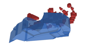
Registered 3D Parcels
The system was developed using micro-services system architecture. ArcGIS was selected as the core GIS platform.
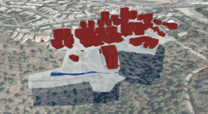
3D Parcels in 3D GIS