
Underground Infrastructure Solution for Water Engineering
Note: this product is available in a separate version designated for ZWCAD under the name CivilCADz Pipes
CivilCAD 10 Pipes includes complete set of tools for infrastructure pipelines planning including water, sewage, drainage and cable systems. Supporting both design and surveying aspects of upper and underground infrastructures, CivilCAD 10 Pipes offers limitless design capabilities.
CivilCAD 10 Pipes intuitive task-based interface supplies the engineer with unique set of tools to easily handle design phases distinctiveness.
*A unique model for the design of gas pipelines is included in the CivilCAD 10 Roads package.
CivilCAD 10 Pipes Features
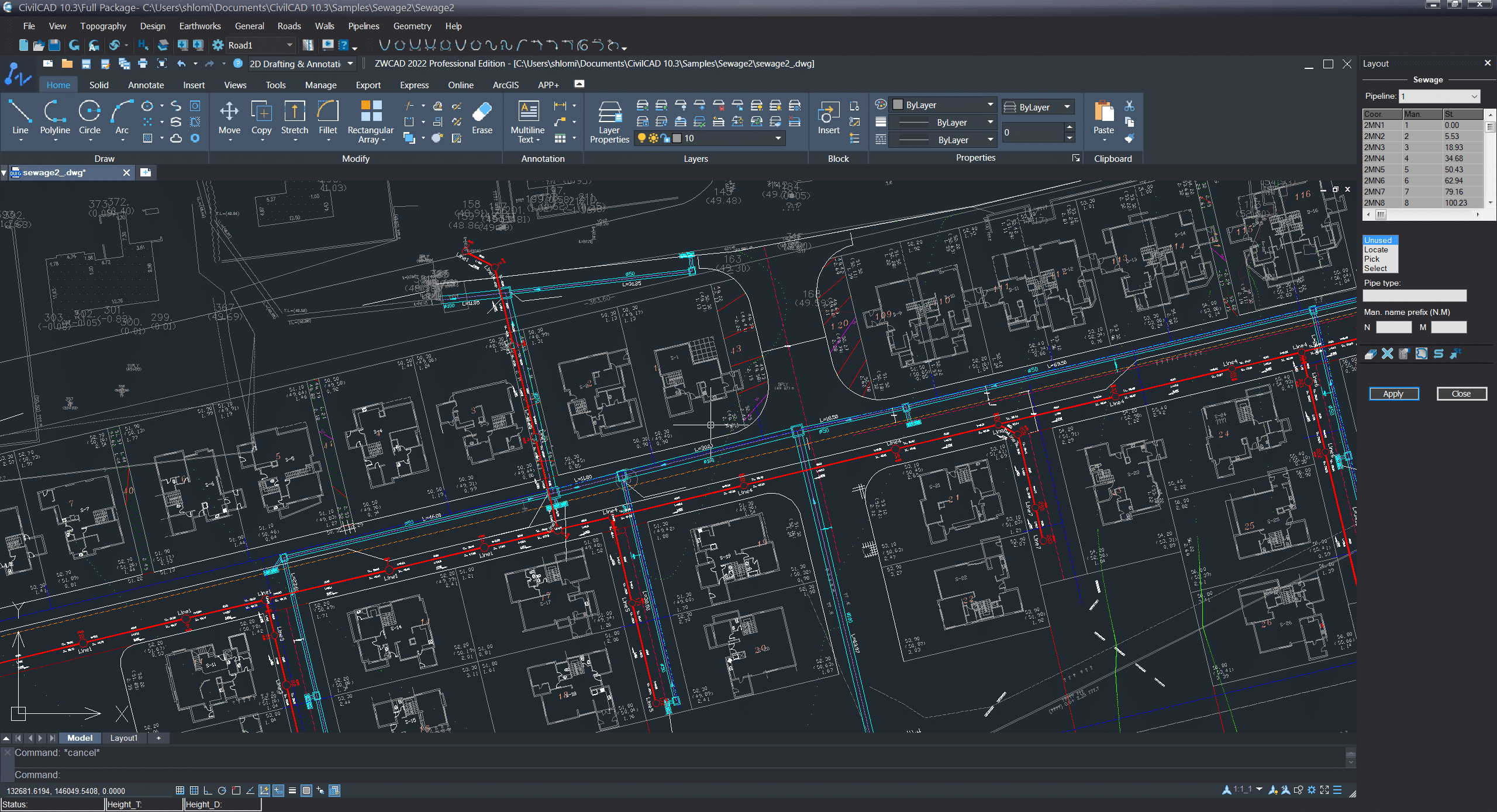
Pipelines Layout Design
- Working in a full BIM (Building Information Modeling) environment with interactive BIM models.
- Pipelines alignment and layout tools for the design of the pipelines network.
- Automatic display pipelines data labels on the layout such asManholes names, I.L., T.L., Depth, Lengths, Flow direction, Slopes, etc., and associate these labels with the appropriate infrastructure components.
- Automatic detection of intersection points with crossing infrastructures in 2D and 3D.
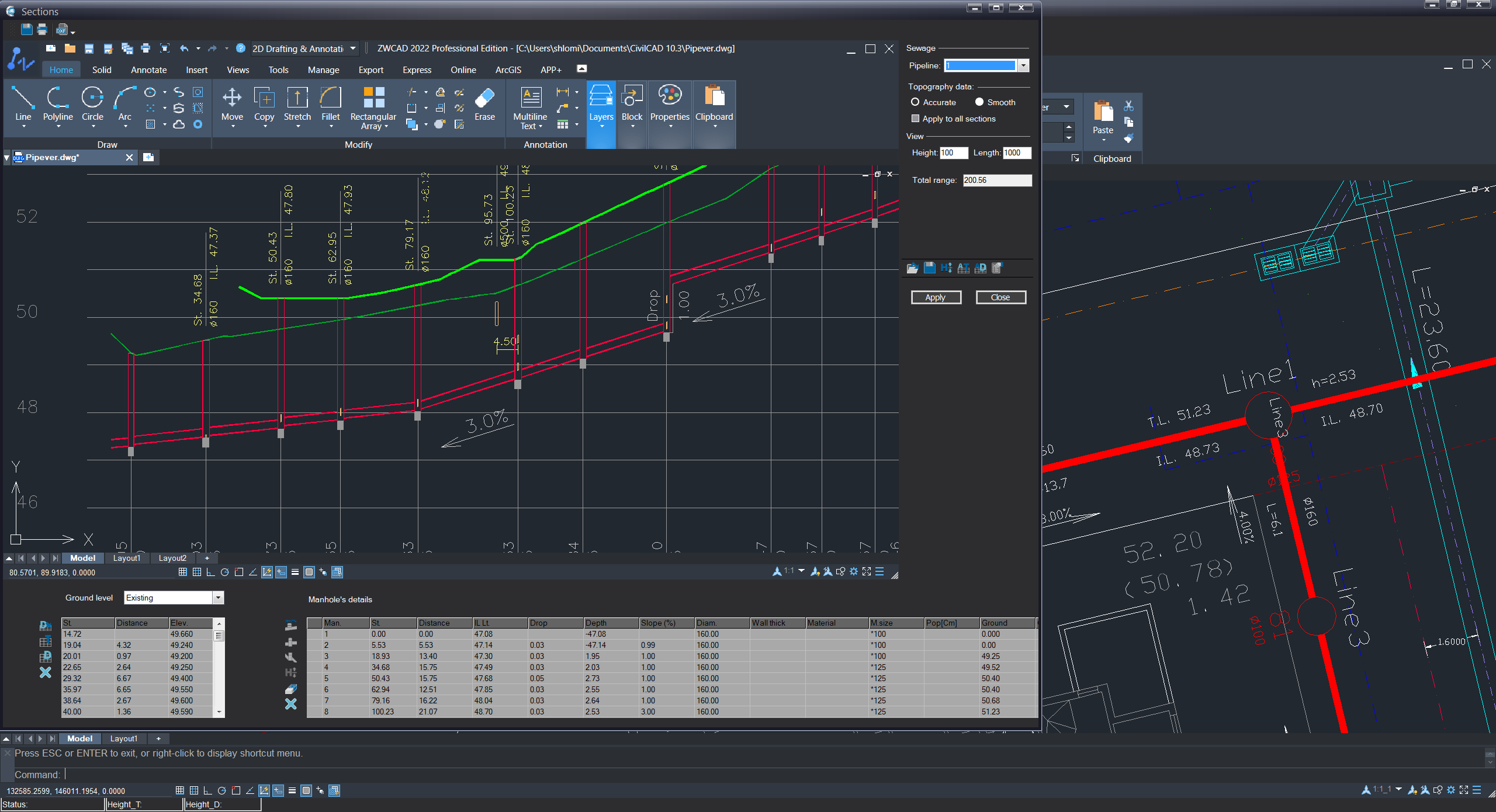
Detailed Section Design
- A separated and designated sections window which allows to interactively design in both graphical and tabular way.
- Broad toolset for defining pipeline depth, slopes, drops, manholes depth, manholes diameter, materials in an easy and flexible environment.
- Interactive updates between sections and layout design.
- Detected intersections points of crossing infrastructures are displayed on the section in their actual depth and size or using default parameters.
- Simultaneous presentation of existing and designed ground levels.
- Advanced features to increase design efficiency such as automatic design, safety distances (from other infrastructure), minimum pipes cover, w
- Water pressure and air valves positioning along pipelines and more.
Comprehensive Reports and Plotting
- Manholes report which includes list of all manholes, depths, I.L., coordinates etc.
- Quantities reports generation.
- Discharges report.
- Detailed reports: A summary of IPs- manholes, depths and sizes, existing and design ground level and more.
- Reports can be printed, exported to Excel, or embedded on the drawing.
Reservoirs and Dams Design
- Unique method for reservoirs, dams and ponds design (requires CivilCAD 10 Roads).
- Balanced earthworks calculations.
- Production of operational plans (scraper plane and sections).
- Water Levels based capacity computations.
- Multi ponds design supporting shared embankments and slopes.
- Special features allowing reservoir bottom-surface elevations design.
*This unique model of Reservoirs and Dams design requires CivilCAD 10 Roads Package
More information about CivilCAD Pipes can be found in the tutorials here