
IGIS – Infrastructure Geographic Information System

Problem Definition
The municipality/company responsible for infrastructure is responsible for consolidating and locating its infrastructures’ data within a reasonable period of time. Due to a lack of a central system, information is lost, duplicated, and/or simply not found when needed. Consequentially, either short or long-term decision-making processes in these organizations are erroneous because of lack of information, and affect future designs that are derived from the same patterns.
IGIS – The Solution
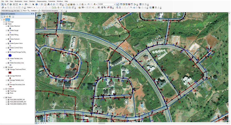
IGIS system saves and files the infrastructures data in a convenient, quick and simple form. The system combines working with AutoCAD environment (see technology – GIS embedded environment) including work settings (regional map/municipality map), and drawings layers of various infrastructures (water, gas, cables etc.), with a textual database of the Infrastructure elements such as pipe segments (pressure pipe, gravity pipe), valves, gauges, manhole and more. The data, constructed from the drawing and the textual data, is kept in a central database connected to the Internet, which provides immediate access to data from every computer on which the system is installed, including field access using laptop computer or PDA.
Work Procedure
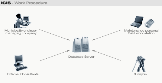
- The database, including the map and textual data, is defined and located on the client premises or Sivan Design offices according to the customer’s choice.
- Access to data base is attainable to any user with a user password:
- Municipality engineer/ managing company – access from office user station allows receipt of data and statistical reports in addition to data update according to need.
- Maintenance personal – access to data from the field via laptop (connected to a cellular phone) or PDA, with real-time access to data and data updating.
- External Consultants – receipt of maps and updated water infrastructure status via their office Internet.
- Surveyors – map data update from surveying office.
System Advantages
- Expert level works in AutoCAD drawing environment (GIS), with no designers or surveyors files conversion, to or from the system.
- Leading SQL Server database, with unlimited data storage capacity.
- Simple windows-based application running over the internet or in a Local Area Network.
- Centralizing of all data in one database avoids duplicity of information.
- Collaboration of data between all potential users including decision makers, designers, consultants and field experts from anywhere in the world, via the Internet.
- Access from the field to extraction and update of data.
- Receipt of statistical reports according to any desired method.
- High precision system accuracy – up to 1 Cm.
- The best drawing environment (GIS engine – AutoCAD MAP based engine) that supports full and partial control over the drawing, including real-time zoom in/out, smooth movement on the drawing and more.
- Links to images and original drawing files of the infrastructure elements.
- Simplicity of operation.
- High data security utilizing access levels according to user.