3D-GIS for Utilities and Underground Infrastructure
When used f or infrastructure and utility purposes, the 3D-GIS in the Cloud rapidly provides evident advantages. The application converts the cluttered labyrinth of infrastructure meshes (e.g. water, sewage, gas, electricity, telephone, etc.) into a clear and easy to understand 3D visualization. This provides the ability to make collision-free plans of the entire underground infrastructure and their facilities. The application enables utilities to plan and coordinate an effective distribution process of their services. This results in an efficient and economic use of their resources. In additional to the utility’s potential financial gain, citizens profit a better service that minimizes the interruption in their daily living. Well planned and coordinated infrastructure distribution became highly important and feasible goal to both the utility and the public and its most common advantages include:
- Prevent repetitions
- Avoid resources and time waste
- Minimize pedestrians and vehicles traffic interruption
- Maintain uninterruptable daily life during works

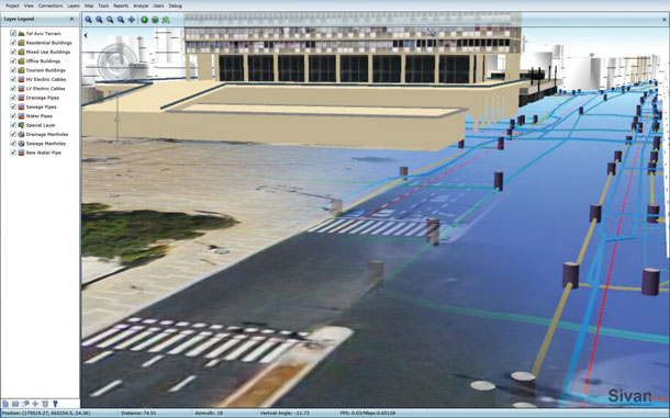
3D GIS view of underground infrastructure
The application creates a detailed Smart 3D City model of both the above and below city grounds. The model includes not just the built environment but also subsurface features such as utility, sewage, drainage and any other underground network or facility. The model includes maps and imagery that are placed on their exact spatial location based on their position and elevation information.
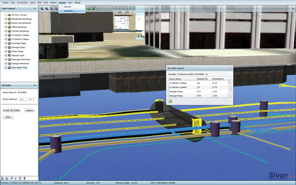
GIS information has been reformed to meet the 3D model display needs and includes new 3D features such as pipeline, 3D buffer, spatial lots, parcels and sub parcels while preserving accurate three-dimensional displacement distances, boundary buffers, expropriations, etc.
Advantages of 3D-GIS in Infrastructure Planning
- Visualize underground features and their relation to the 3D space
- Realistically model subsurface features of underground networks and facilities
- Optimize facility placement or resource location
- Approximate a more realistic feature space needs
- Identify processes and spatial patterns when looking for problems solutions
- Create and maintain building, infrastructure, and utility networks
- Examine and calculate volumes of subsurface structures and networks
Detailed Underground Feature Information
The 3D model is highly detailed and contains additional information about subsurface structures and features that can’t be achieved when working in 2D. The added information consists mainly from Z values and includes depth, elevation, wall thickness, etc. Each structure contains information about the main material it is constructed from to achieve a realistic appearance.

3D GIS provides 3D buffer of an underground pipe
