
Roads Construction, Design and Earthworks Calculations
Note: this product is available in a separate version designated for ZWCAD under the name CivilCADz Roads
CivilCAD 10 Roads is a comprehensive package for the roads designer, roads construction companies and quantities surveyors. The software combines powerful design options, accurate and high-speed results, and supreme usability setting new standards for roads engineers worldwide.
Civil engineers, surveyors, earthworks and land development contractors which are using the software, acknowledge CivilCAD 10 Roads as their primary tool for getting the job done.
CivilCAD 10 Roads Features
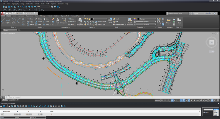
Horizontal and Vertical Alignment Design
- Working in a full BIM (Building Information Modeling) environment – all roads’ features including geometry, surfaces, and drainage are BIM models.
- Complete horizontal alignment design set of tools including curves transition of clothoid or cubic parabola.
- A separated and comprehensive vertical alignment window which allows to interactivity design in both graphical and tabular way.
- Interactive changes between the horizontal and vertical alignment.
- A reach layout drawing display separated to thematic layers including geometric data, sections, side slopes, elevations along the road’s components (centerline, sidewalk, median etc.), ditches, roads edges, cut-fill transition points and more.
- Ability to extend existing road design using automatically obtainable parameters.
- Rapid and accurate geometric calculations along roads.
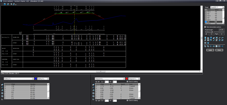
Powerful Cross Section Design
- Usage of typical cross sections or user defined cross sections – each cross sections segment can contain type/cover (asphalt, sidewalk, garden etc.), base-width, height/slope, and associated blocks. Different segments for structures top-level and design/sub-grade.
- Creation of sub layers associated with existing, structure and design layers are differentiated and displayed according to the defined material and thickness.
- Applying changes to a specific cross section, group of cross sections, or all cross sections.
- Various cross sections closures capabilities – automatic closure of structure to design, closure by slopes in cut and fill, closure by slopes defined by roads heights, closure to land development, berms, changing side slopes by the closure depth/height, closure with a guard rail and more.
- Comprehensive side-ditches and gutters mechanism which allows full control on various use cases and conditions – embankments slopes, bottom width, depths by conditions (in cut/full and depth conditions), type of ditches (protective ditch, ditch in fill, concrete/earthworks), shoulders and more.
- Ability to attach cross sections segments and side-ditches to an offset reference-line in the layout.
- Detailed underground and upper ground crossing utilities display in cross sections.
- Automatic identification and projection of parallel and intersecting roads design levels on cross section.
Advanced Design Supportive Capabilities
- A comprehensive module for super-elevations which allows to define super elevations segments and runoffs in a specific or automatic manner, define the shoulders and other cross sections segments super elevations, and more.
- An innovative junctions design including typical sections, islands, roundabouts, and detailed reports.
- Define bridges and tunnels in the design including earthworks volumes calculations and reports.
- A unique and advanced visibility module with export and reporting capabilities.
- Export and import data in various formats such as LandXML, IFC, SHP etc.
- An all-inclusive retaining walls design module which allows to define walls horizonal alignments automatically (parallel to the road) or through user-defined alignments, walls vertical alignments using initial parameters or specific top and bottom elevations and more.
- Intelligent and balanced volumes calculations and reporting per layer/sub-layer.
The CivilCAD Roads package includes all of CivilCAD Standard package capabilities. More information about these capabilities can be found here.
More information about CivilCAD Roads can be found in the tutorials here.